Category Archives: South America

Chile III – Trekking the W
Hiking the W Trek to see Torres del Paine in Chilean Patagonia was one of the original drivers for our trip, so finally getting there 11 months later was pretty exciting! Big cheers go to Gareth & Michelle for giving Xavi the awesome book which seeded the idea!!
The previous 21 days on a boat wasn’t the best physical preparation for a 75km trek, but our time was running out with a pending onward flight out of Buenos Aires 10 days later, so we weren’t going to let that stop us. We spent a day preparing in Puerto Natales, another small town now very reliant on tourism since Torres del Paine has grown in popularity. We didn’t make it to the few tourist attractions of town, but instead were busy organising food, renting equipment, taking in the Erratic Rock Info Session (3pm daily @ Base Camp Pub), deciding the best route and calling home with the good news of our recent engagement. After all that, at last we were ready to set off.
The W Trek is a 75km W shaped trail in the Southern Patagonian Ice Fields at the end of the Andes, which visits the spectacular Torres del Paine (Paine Towers). There was a lot of confusion about the best direction to walk with many sources giving opposite recommendations so in the end we left it up to chance with the weather.

W Trek marked in red – red & blue together is the O and they call the red, blue and yellow combo the Q.
We caught buses in to Laguna Amarga starting point with a quick (compulsory) stop over in the National Park Office to get the briefing, weather report and pay entry fees. It was here we made the last minute decision to walk from east to west in the hope we would miss the upcoming rain when we visited the Torres. So we set off from Hotel Torres with the busload of other trekkers. We sadly left the less crowded 9-day O loop for the more hard-core trekkers & people with more time, but hope to go back some day!

The start of the trail from the East with the cloudy Torres in the distance on the right.

The 3.5 hr hike to Campamento Chileno was a good first day intro into what was to come, 4 days of incredibly beautiful scenery and some rather crazy weather! It really is four seasons in one day, and the wind that rips through the valley was enough blow sunglasses off our faces and knock us over. The walking stick became a trusty companion after that as the path often followed cliff edges which combined with the gusting winds deserved respect!


Rolling stones – some caution signs cause the opposite effect of what they’re made for…
Just after we finished setting up our tent at the camp and were getting ready to hike on to the Torres, we couldn’t believe our eyes!! Walking through the tents we ran into some familiar faces – Alex and Anne-So, mates from Sydney!! Who could have imagined that we would meet friends who we hadn’t seen in about a year (and had no idea they were in the area) in the middle of a trek…they were on their second last day after walking the trek in the opposite direction! Such an awesome surprise!!

Reunion at Torres del Paine!!

We had a great time catching up over the walk up to the Torres and over our camping stoves cooking meals. Luckily and thanks to them for the wake-up call, we made it in time to see the sunrise at the Torres the next morning too! Despite overnight rain, the morning was fine and with our headlights we tramped up to see Torres del Paine again following the track and the rough trail of moving headlights of other hikers ahead. Once at the top, we sat huddled together with all our warm clothes on to combat the cold morning air, waiting for the sun! It’s strange to think that a rock face can be so beautiful, but the way the Torres change as the rising sun lights them was incredible!

The sunrise just beginning opposite the Torres.

Before the sun really came up…

Then the light started coming over the other mountains! Talk about the golden hour!

After a good breakfast and farewell-ing Anne-So and Alex we started out in the rain on our way to Campamento Italiano for what was the longest day of walking (approx. 21 kms, 5-6hrs). The trail through the wilderness was beautiful, yet we didn’t feel too isolated as we crossed many other trekkers of all ages completing the trek with us or in the opposite direction. The weather cleared up just after Campamento Chileno, and we were treated to excellent views of Lago Nordenskjöld and los Cuernos.

Poor horses have to carry the gas in to the privately run campsites.


Los Cuernos (The Horns)
The four seasons continued to jostle each other to come out and by the afternoon of the second day it was really hot and we were in need of some refreshment!! We found a small desire path that led off the trail and down to the pebble beach by the water’s edge and had a refreshing swim in the glacial waters! It did wonders to give us the energy to continue on to the campsite!

Glacial waters made for a very quick swim!

Lago Nordenskjöld
We arrived at camp at about 6pm, well and truely ready for a rest! For our third day, we planned to hike the Valle Frances, a 5hr return trip up and back the middle leg of the W and then arrive to Paine Grande (the bottom point of the left leg) another 2hrs later. Unfortunately, the weather wasn’t on our side and the horizontal rain turned to sleet and then snow so we didn’t see too much. It was so cold, our fingers could hardly work to press the shutter button on the camera. Coming back which in the most part was mildly downhill, we had to run to keep warm because we were totally soaked.

Great weather for hiking!

Valle Frances (French Valley) – in a brief clearing in the clouds we could make out the back of the Torres
From Campamento Italiano to the Refugio Paine Grande, the terrain changed significantly again. There’s a large section which suffered from a huge forest fire in December 2011 caused by a backpacker burning toilet paper and the effects are still clearly visible! When we got closer to the lake again, we could see the strong winds coming, pushing ripples across the lake, they knocked us about a bit, but we managed to stay standing this time.

Forest of recovering trees – a forest fire ripped through the area in trees


It’s always a good feeling during a long hike when you start to see the campsite ahead!!
Our first hot shower in days was waiting for us at Paine Grande camping site and after a day walking in the rain it was much appreciated!! That night we left Xavi’s shoes and backpack minus any valuables under a shelter to dry (as we had done with our stuff in the other free campsites along the way) and woke up to find it was missing. After travelling in some of the most dangerous countries in the world, who would have thought that we’d be robbed in the “most developed” country of them all!? Luckily however, Xavi’s giant hiking boots were not to the theif’s liking and were left there, so after about an hour searching the area for the pack and talking to the authorities, we decided to continue on with the last leg of the trek, a 22km, 6hr return loop to Refugio Grey.

Our first dry morning of the trek!!

Enroute to Grey Glacier
It was yet another day of amazing scenery! Despite having lost our lunch in the backpack, we calculated and rationed the remaining biscuits and trail mix that were in my backpack over the day (small snack every 30mins). After leaving Antarctica, we weren’t expecting to see any more icebergs on the trip, but were surprised to see quite a few more on the way to Grey Glacier. This leg of the W has great views of Lago Los Patos and Lago Grey and viewpoints of two faces of the glacier.

Lago Los Patos

Glacier Grey
One thing we didn’t see much of on the whole trek however were animals, apart from a few condors occasionally floating overhead we were surprised at the lack of wildlife. Locals refer to the W as ‘going to the city’ (busy with plenty of tourists) so probably that combined with burnt forests etc is keeping them away in the more secluded sections of the park.
We would have loved to keep on going to the next bridge after Refugio Grey which we heard had even better views of the Glacier, but we were running out of time, and were pretty tired by this stage so we went back to Paine Grande to wait for the catamaran which would take us back to Pudeto. The boat was full of familiar faces from the last few days on the trail and we all soaked up the last spectacular views of the mountains on the way back to civilisation.

The home stretch, last km!!

We never got tired of looking at these mountains!!
Back in our room in Puerto Natales and minus a big backpack, we faced the difficult task of trying to fit all of our belongings into one pack and few extra small bags. Luckily we were travelling relatively light and my bag is big!! So after hardly any rest at all, we were up the next morning in the dark to get to the bus stop, cross to Argentina and move on to our final destination in South America…Buenos Aires!! It’s kind of a sad feeling when you know the trip is coming to an end, but we’re still living in the moment and enjoying the ride. More to come soon from BA and another visit to the wonderful Argentinian family!!
Lots of love,
Xavi & Sal

Argentina III – Hiking, glaciers & the end of the world…
Back in Argentina for the second time, although now much further south, we woke up on the overnight bus to an incredible sunrise over the dry pampa (plains) with towering mountains in the distance. We were reaching the much anticipated hiking capital of Argentina!!

Our first views of Argentinan Patagonia

We used El Chaltén as the base to visit Fitzroy Mountain otherwise known as Cerro Chaltén (Chaltén Hill) which comes from an indigenous word that meant smoking mountain, which is quite fitting as it’s almost always covered with cloud and they thought it was a volcano. It’s situated in the Southern Patagonian Ice Field and interestingly while it is considered part of Argentina, in the surrounding area of the map there are at least 50kms of border that is still to this day undetermined because Chile & Argentina can’t agree with each other. In fact, El Chaltén the town, was created in 1985 to help secure the disputed border with Chile and the government were practically paying people to move and set up there. Now it’s worth a fortune thanks to the tourist dollar, but luckily for the National Park its extension has been capped so it can’t get any bigger.

El Chaltén Town

On our first day apart from stocking up on a camp stove and gas, which we wish we had bought earlier in the trip (so handy!!), we did a bit of a warm up walk out to El Chorillo del Salto. It’s a pretty, but crowded with tour-bus tourists, waterfall a few kilometres out of town – and was worthwhile to get the legs moving again. When we got home however, I made the most disgusting discovery of the trip…somewhere along the Carretera Austral in Chile…I had managed to pick up headlice! After a very quick trip to the only Pharmacy in town and enduring the incredulous looks from the discreet Pharmacist (…in front of the whole queue of customers in Spanish…What?! the lice treatment is for YOU?!) I rushed home to cure it!!

El Chorillo del Salto
Lice free and all stocked up with porridge, sandwiches and pasta for dinner, we set off for a two-day hike to Laguna de los Tres. About 8kms in, we set up the tent at Poincenot Camp, leaving our big bag inside before continuing for the steep part up towards the lake and mountains. Glacier feeds the bright blue lake and Mount Fitzroy towers behind. With a little more walking up a small mound to the side, we got to the viewpoint for Laguna Sucia (dirty lake) and huddled behind a big rock out of the wind for lunch while being mesmerised by the beauty of the surroundings.

Best tasting water ever!!


Icefall from the glacier

On the way back to the campsite, we took detour down the riverbank another 3kms to the Glacier Piedras Blancas. To get to the actual glacier, we had to climb, crawl and jump over and inbetween big white boulders which was heaps of fun!


The following day, we woke up to rain, no magical sunrise and mysterious noises and whistling which came from some scary looking predatory birds that were hanging out around the camp. We packed up the tent in the rain and set off towards Laguna Torre, passing tight trails through scrub, Madre & Hija (Mother & Daughter) lagoons, more beautiful rivers and streams and forest on the way. There were lots of rainbows around, and the weather sort of cleared up as we went on, but clouds stayed around the big mountain peaks.


Upon arriving to Laguna Torre, another lake backed by striking mountains and fed by a glacier, we attemped to hike further along a ridge to another viewpoint. However, howling, gusting winds were trying to push us off the ridge and after few hundred metres with frequent stops to crouch or hold onto rocks to stop from being blown away, we abandoned the attempt.

We enjoyed the area so much, that after arriving back in town we went straight to the bus stop to change our reservation and stay another day. With that sorted out, we hit the local Parrilla tenedor libre (free fork = all you can eat) for a celebration!
On our last day in el Chaltén we hiked to Loma del Pliegue Tumbado, a 20km round trip with a 1km elevation gain, to get our last chance for a different view of Fitzroy Mountain and to enjoy the area.


There’s rarely a lack of clouds around these mountains!
Next stop on the way down Argentina was El Calafate, a very touristy town and not a place we would recommend to visit, however to its credit, it does have an excellent icecream shop!! We didn’t go there for the town though, it’s the closest big town to the Perito Moreno Glacier.


Spot the Rhea (South American version of the Emu) in the middle – best camouflage ever!

Perito Moreno Glacier
Perito Moreno is spectacular! It’s a massive (250km2 in size and 30kms long) arrow-shaped wall of ice coming down from the mountains, pushing into the turquoise Lake Argentina. It is one of only three Patagonian glaciers that is actually advancing – the pointy part of the arrow moves 2m a day while the sides move 40cms. Despite this, the most impressive part was seeing and hearing sections falling off into the lake, the cracking noise is impressive and the resulting wave also.

Small chunks are constantly falling off


This little owl had a prime glacier viewing spot
With only 3 days and 870kms to go to get to Ushuaia for the boat to Antarctica, we were in for the killer bus journey to the end of the world! Starting at 3am, one bus change, a ferry ride across the Magellan Strait, two border crossings and 18hrs later we arrived in Ushuaia. From the outskirts it looks a very industrial area with docks and shipping containers, but once in the city it has a certain isolated beauty.

Commerson’s Dolphins played in the ferry’s bow waves.


Argentina likes to claim that Ushuaia is the end of the world…


English Pirate Boats are prohibited from mooring in Ushuaia! The Falklands/Malvinas Conflict is still a controversial topic – no agreements reached as yet!

Apart from borrowing gear and preparing for Antarctica, we fit in a visit to the Glaciar Marcial with a Dutch couple from the hostel. After Perito Moreno it wasn’t impressive, but the views of Ushuaia were great.

Glaciar Marcial

Ushuaia & the Beagle Channel from the Martial Glacier
Packing for Antarctica was pretty simple in the end because we had no option but to take all of our stuff as it was another one way ticket flying into Punta Arenas, Chile after the trip. So after helping pack the Icebird (our sailboat) with supplies and getting another passenger’s motorbike onboard for the trip down to Antarctica we were set for the biggest adventure yet!!


Preparations on the dock

Kayaks check, food check … motorbike check
Stay tuned for more from the icy waters of Antarctica!!
Love Xavi & Sal

Chile II – Puerto Varas, Chiloé y Carretera Austral
After staying with family and friends in Argentina and Chile for almost a month, taking the zillionth overnight bus of our trip regained its original excitement.
Our destination was Puerto Varas, a charming town with German heritage that breathed through historical buildings and bakeries.


Puerto Varas beach, by Lanquihue Lake


After exploring the town and meeting new friends at the hostel, we headed together to the Petrohué falls and Lago de Todos los Santos for a day hike.

Petrohué Falls

The lake is crowned by the Osorno volcano which, with a permanent snowed peak, is used as a ski resort in winter. We have never been to Japan, but if we had seen someone wearing a kimono, I’d have sworn we were in front of Mount Fuji!

Volcán Osorno
The hike was beautiful except for the harassment of the tábanos (horse flies) that only appear in this area for 1 month in the entire year. How lucky were we?? We even tried to get rid of them by swimming in the chilly waters of the lake…but then our heads were their only available target… so we resumed the walk shortly after.

Feeling exhausted but happy to have shared a great day with new friends, we all decided to chip in and buy the ingredients to make our own home-made Pisco Sour. It’s the national drink in Perú and Chile which is made with a grape liquor called Pisco, similar to the Italian grappa.

I asked a Chilean guy to supervise our cocktail making and the only thing he disapproved of was the alcoholic percentage of our pisco. We got the 40° instead of the 35° we were supposed to use… but no one complained about it really. If you want to make pisco: 1/3 pisco, 1/3 lemon juice, 1/3 sugar syrup, 1 egg-white for every litre of pisco, sugar and ice. Mix all the ingredients but the egg-white, which you will add at the end and shake the whole cocktail lightly (cocktail shaker) or blend it for a short time. You don’t want it to foam too much. Enjoy!
From Puerto Varas we were supposed to go to Puerto Montt and catch a 4-day ferry to Puerto Natales. However, the ferry was booked out until 2 weeks after, so we decided to visit Chiloé, Chile’s second biggest island. We loved Chiloé for many reasons, first you have to access it by ferry (there’s a project to link it to the mainland by a long bridge) and we saw plenty of sea lions on the way.

Ancud

Spanish fortress in Ancud
Ancud, in the north, was the first town we visited. While this town is quite famous for its Pingüineras, we decided to save the bucks and walk its calmed streets and fortresses instead. There was also a museum containing reproductions of the most important UNESCO recognised churches on the island, a unique example in Latin America of an outstanding form of ecclesiastical wooden architecture.


Seafood is quite popular in this area, so I was quite excited to try Curanto, a local dish made with a mix of mussels, clams, sausages, pork knuckle and potatoes that is smoked in a pot or buried with a local leaf. The smoky flavour is beautiful and Sal didn’t complain much because there was meat involved. The mussels were some of the biggest and nicest we had ever tried and one of them came with a little pearl that I almost swallowed, bingo!

From Ancud we headed south-west to visit Chiloé’s National Park. Once the tent was set, around midday, we realised that we had missed all the buses going to «El Muelle de las Almas» (The Souls Dock). We tried renting bikes but the prices were just a rip off… so we started asking locals if they wouldn’t mind taking us there for a fair price. People in Chiloé are really nice and it didn’t take us long to find a driver.

El Muelle de las Almas
El Muelle de las Almas is this beautiful spot close to Cucao, known in the local traditions for being the place were souls start their journey. A few years back an architect built the dock that seems to lead to eternity. The legend says that souls carry two coins and are taken by the boatman to the resting place. Those souls without coins are stuck in the area forever, and you can still hear their cries mixed with the crashing of the waves.

Chiloé is a place of superstitions, legends and mythological creatures. Inhabitants talk about them naturally and some still believe in them. One of our favourites is «El Trauco», a kind of ugly forest dwarf who is able to seduce women. Back in the day, when there was an unexpected pregnancy, people used to blaim El Trauco, so funny.

The day after we went to Castro, on the east side of the island. Castro is famous for its «Palafitos», colourful houses that rest on wooden columns over the sea and that give the town a really cool look from the water.

Palafitos in Castro

Castro’s eye-catching cathedral

More Palafitos in Castro
From there we went to Quehui (pronounced very close to Kiwi), a tiny island 2 hours from Castro where they were celebrating a «Fiesta Costumbrista» (Folklore Party). If you ever go to Chiloé, make sure you’re there between the end of December and Mid February, when different towns organise these parties.

Quehui

Quehui

The few inhabitants in Quehui welcomed the 2 or 3 boats coming from Castro with open arms. We were some of the few tourists and were lucky to meet a Chilean family who told us about the traditions on the way to the island. All the action happened in the main square of the town, more like an open field than a square really, where they had set up 4 tents cooking local dishes (Curanto and Patagonian lamb BBQ) and a little stage.


Curanto in the making
The master of ceremonies led the party and introduced the local dancers, a little procession, a music band and, to everyone’s delight, the popular games: tug-a-war and wood-chopping.

Regional dance

Knitting demo
I took part in the tug-of-war, joining the team of non-locals. We beat them on the first round (whether they gave us advantage on purpose or not will remain a mystery), but trashed us in the next 2 rounds. Good fun anyway.

When volunteers were asked to compete against the local lady in the wood-chopping comp I gently pushed Sal forward. When the locals heard that she came from Australia she automatically won some supporters, mostly male I should say, and a fierce competition started. Following the advice from the cheering audience Sal started rolling the log to cut it from different angles. A dodgy move was allowed when a guy swapped the local girl’s axe for a different one and, probably 5 hard minutes into fierce chopping, the local girl managed to split the log. Sal was very close though and the locals recognised the really good effort.

Picture the crowd yelling: Australia! Australia!
The day after we took another ferry that crossed us back to mainland, into Chaitén (not to be confused with El Chaltén in Argentina). Chaitén was buried in ashes in 2008 after the eruption of a volcano with the same name and it’s located on the Carretera Austral.


Chaitén
Having missed the ferry between Puerto Montt and Puerto Natales, the Carretera Austral was our only way south; however, even in summer, the frequency of buses is scarce. This road was not built until 1980 and it was one of the few positive things that Pinochet did during his dictatorship. As a result, people who live in the area are quite fond of Pinochet and have even named towns after his wife (Santa Lucía) or his government team (La Junta).

Fly fishing is one of the favourite hobbies in the area
A couple of nights before we had also received the best news of the trip. After a few cancellations, we were offered a spot on a sailing boat to go to Antarctica! While we had never budgeted for it, the last minute deal and the savings from the previous months allowed us to make it (sacrificing little luxuries paid-off!). We were literally jumping on the bed celebrating the good news!
This meant that we only had a week to get to Ushuaia, more than 2,000km south, with unknown modes of transport and on one of the most isolated roads in the world…challenge accepted!

You can spot plenty of glaciers in Carretera Austral
We arrived to Chaitén at around 6pm and decided to give hitch-hiking a first try despite it being late. Not long after, we were sharing a ride with a guy who organised fly-fishing trips in the area. We drove past beautiful parks and glaciers that we hope to visit more calmly in the future with our own car and he left us near a nice free-camping spot by a glacier river.

Walking in the middle of nowhere, after our first ride
When we were convinced we were going to spend the night in the middle of nowhere, a bus passed by carrying just a couple of Chilean backpackers. It wasn’t a scheduled trip, but the driver had to pick a group of tourists from a town down south the day after. We got off in Puyuhuapi where we camped around midnight, having covered almost 200km.

Waterfalls close to Coyhaique
The day after we were one of the first to hit the road and it paid-off. A really nice truck driver from Coyhaique gave us a lift all the way there (220km), but the road conditions meant driving all morning.

After lunch we walked to the other side of town to start hitch-hiking again, but this time we weren’t so lucky. A lovely lady took us 20km south, next to her farm, and from there in the absence of rides, we walked for around 2hrs, carrying our bags further into the middle of nowhere.

The Andes from Villa Cerro Castillo
We were starting to look for a secluded spot to hide from the wind and spend the night, when salvation arrived in the form of a combivan driven by 2 Americans who had also been hitchhiking recently.

They were coming back from a 3 day hike called Cerro Castillo, highly recommended if you have the time and they left us in the town by the same name (Villa Cerro Castillo, 95km south from Coyhaique), where we spent the night in a cheap guesthouse with the company of 2 Chilean ladies and 3 Israelis.
The morning after we spent 2 hours and a half waiting for a ride.

In the end we had to pay for one but they took us right where we wanted to go: Puerto Tranquilo (123km south) by the Lago General Carrera, a stunning turquoise water lake that shares borders with Argentina. Over there we reunited with the 2 Americans and the 3 Israelis and we got the chance to visit the «Catedral de Mármol», a series of marble formations in the lake.


Dog face!

The Carretera Austral still continues for another 500kms or so until Villa O’Higgins, but we had already spent 3 nights just to cover a bit over 600kms and we only had 6 more days to get to Ushuaia.

General Carrera lake changes its name to Buenos Aires lake once you cross the Argentinian border
That’s why when we were offered a lift to Chile Chico (at the Argentinian border) by a friendly Chilean couple, we didn’t think twice and offered them to pay for the petrol (cheaper than the bus). We left the next morning with them for another half a day driving journey through beautiful landscapes.

We had made it back to Argentina but we had just scraped the surface of Carretera Austral, which stays on our bucket list in big letters. We’ll be back one day with our own wheels, definitely the best way to explore its pristine nature.

Coming soon, our 4 day incursion into El Chaltén, the hiking capital of Argentina!
Love, Sal & Xavi

Chile I – Santiago & surrounds
After a long drive from Mendoza, the marathon border crossing in the Andes and the typical map-related arguments (it’s complicated when the map is missing streets and half the names!), it was a relief to finally arrive in Valparaíso.

Valparaíso is a rather curious city, it was built on top of a group of many steep hillsides overlooking what was once one of the most important ports in the Pacific Ocean (and the world!). The big commercial shipping port gives it a gritty feel, as do all the once grand, but now dilapidated buildings, but this is mixed in with colourful houses on the surrounding hills, an unusual system of funicular lifts, UNESCO world heritage recognised streets and our favourite part, excellent graffiti murals.


It was once the most important port in the world due to its location as a convenient stopover point for ships travelling between Europe and the Californian gold fields. So it was full of wealth and opulence, European immigrants and of course sailors, until the Panama Canal was built and most boats opted for the shortcut through Central America instead.

Valparaiso Port

Signs of its former glory…

Given the hilly nature of Valpo (as the locals call it) you really have to wander the streets to get a feel for it, so we sought out the local tour4tips for a walking tour (very recommendable!). There are 45 cerros (hills) surrounding the bay and the houses & buildings have been built to measure, adapting to the terrain. In order to access the hills apart from lots of stairs, there are funiculars (or ascensores – lifts), many of which are more than 100 years old and still in operation!

Built to measure

Ascensor Cordillera


Funicular operator at work

Ascensor Concepción
After visiting the main sights down on the flat area of town, we took a funicular up into the hills Cerro Alegre and Cerro Concepción where we started to see the street art culture coming alive. Graffiti remains illegal in Valparaíso, however the murals are used as an ingenious way to avoid unwanted damage and tagging on the walls of buildings and houses. We spent hours wandering the cobbled streets seeing vibrant, abstract and sometimes a little shocking works of art. Valpo attracts many famous artists both local and from around the world who come specifically to make murals there.


Several artists stood out from the crowd as we started to see their work on many different walls. Our particular favourites were murals containing clown-like dolls usually with a lot of symbolism and indigenous culture references by Inti Castro, humming birds and other native animals by Charquipunk, and strange half fish half man murals by Daniel Marceli.

Inti Castro Mural forms part of the Valparaíso cityscape

Daniel Marceli’s half fish half man

Charquipunk’s Humming Birds

Three artists in one mural!


Even the bartenders are creative!
We also made a quick day trip to the more upmarket neighbouring city, Viña del Mar, to check out the beach and to see one of the only Moai statues from Chile’s Easter Island that is now on the mainland.

Roser, Antonio & the beach at Viña del Mar

Quiltro!

We won’t make it to Easter Island on this trip but seeing a real Moai will do for now
Once in Santiago, we hit the streets again for the local tour4tips and, with Roser and Antonio, we very ambitiously signed up for both morning and afternoon walking tours (6hrs in 30 degree heat!!). It is another city of vast contrasts and we traipsed from the beautiful green parks, through the old, but neat city centre, to the central market and poorer neighbourhoods and the grand cemetery.

More Inti Castro Murals in downtown Santiago

So hot the kids were swimming in the fountains!


Ollucos – some sort of root veggie in the Mercado Central

Cementerio General – full of impressive tombs like these!

Contrasts – neighbourhood near the markets, just 10 mins from the city centre

Amazing Murals in the Universidad de Chile Metro Station

It’s one of the world’s most impressive train stations
We were introduced to many of the city’s Quiltros (stray dogs) who joined us on the walking tour as they do every day protecting us from other dogs and, strangely enough, bald men, until we entered the metro where they know they are not welcome. Quiltros are very friendly and are generally a loved part of the society. Locals and businesses leave out bowls of water and food for them and there are even dog houses installed in the local parks.
Another intriguing tradition we came across in Santiago is the Café con Piernas (literally coffee with legs). So the story goes that when cafés were first introduced to Santiago, they were big failure until, in order to create demand, some clever minded businessman decided to create a café where the coffees were served by very short-skirted waitresses. This has since evolved into a scale of coffee shops, ranging from the basic short-skirt variety, all the way to the to the cafe’s with darkened windows that look like stripclubs – only that it seems to be perfectly normal for the local businessmen to be in there for the morning coffee meetings.

Café con piernas – G rated version
We also learnt loads about Chile’s 1973 military coup where Augusto Pinochet overthrew Salvador Allende’s socialist government to start a 17 year dictatorship. As we found in Cuba, it was very interesting to talk to various different people about Pinochet’s military dictatorship which lasted until 1990 and understand the different points of view. We also visited the Museo de la Memoria, which houses interesting exhibits about the military coup and events (violations of human rights etc) that followed in Chile’s history. They even have a station where you can listen to Allende’s last address to the nation which he broadcast nationally on the last non-compromised radio station during the air-raid attacks on the Presidential Palace. After Pinochet’s troops stormed the palace, according to the official story, Allende was found dead of an apparent suicide, however the bullet entry points potentially suggest otherwise.

Palacio de La Moneda – The Presidential Palace where the military coup d’état took place

More murals in Barrio Brasil on the way to the Museo de la Memoria

Museo de la Memoria
As we still had a hire car with Roser & Antonio, we also got to see some of the surrounds of Santiago on a day trip out to the Cajón del Maipo, another excellent wine region, and the Embalse el Yeso. The embalse is a turquoise dam reached along a rough and dusty dirt road. Unfortunately it was a too cold and windy to stay long and enjoy, but on the bright side the scenery was beautiful and we worked up a thirst for a wine tasting at the Casillero del Diablo on the way home.

Embalse el Yeso


Heading down to the haunted bodega..

El Diablo himself!
After farewelling Xavi’s parents we caught up with our mates Alex & Elena, for an awesome week of fun, catching up, great meals and more exploring in Santiago. We’re so grateful to have been able to stay with such great friends like these along the trip, thanks so much guys!!

Family lunch!!
For the first time, we also tested our recently acquired camping tent on a weekend away to Las Peñuelas. The tent was fine, but the best part was our campfire feast where Alex & Elena showed us a few things they’d learnt to improve an Aussie BBQ while in Chile.

…looks like the boys have just caught some game!

Awesome camp BBQ – including eggs cooked inside capsicum halves!!

Almost calçots..
Speaking of great friends, we also caught up with another old friend from our university exchange in Vancouver (2005), Cristobal, and got to meet his family and friends over a BBQ lunch.

Great Sunday lunch at Cristobal’s

Plus all the neighbours’ dogs came to play

It was great to see you Cristobal!!

We also crossed paths with Pete & Lina again after 3 months!
Between Christmas and mid-January we’ve been staying with family and friends which has been a very appreciated change from the backpackers dorms. Quite possibly our trip would have ended sooner if it weren’t for these mini-breaks! So, sad to leave our mates, but as always excited for the next adventures waiting for us down the road, we set off for Puerto Varas and to discover more of Chile’s south.
Big hugs,
Xavi & Sal

Argentina II – Fiestas con la familia!
This post is writen in Spanish as a thank you to our Argentinian relatives who adopted us during Christmas and New Year’s. Click here to translate into English https://translate.google.com/translate?sl=es&tl=en&js=y&prev=_t&hl=en&ie=UTF-8&u=http%3A%2F%2Fonewayticketon.wordpress.com&edit-text=
Un primo de mi abuelo, Salvador, emigró a Argentina cuando tenía 18 años. Es por eso que una gran parte de mi familia (más grande que la que nunca podría haber imaginado!) vive ahí, entre las ciudades de Buenos Aires, Rosario y la localidad de Firmat. Sal y yo no nos lo pensamos 2 veces y ajustamos la ruta de nuestro viaje para ir a conocerles y pasar las fiestas de Navidad y Fin de Año con ellos.
No hace falta decir que nos trataron como a reyes! Sólo bajar del autobús en Rosario ya nos esperaba la comisión de bienvenida: Nieves, Rubén DC, Marta, Sílvia y Sergio. Con ellos pasamos las primeras horas en Rosario, recorriendo la orilla del Río Paraná, el lugar preferido de los Rosarinos para hacer deporte, salir de fiesta y tomar su ceremonioso mate.

Río Paraná y Rosario

Con 38º todo el mundo se va al río!
Rubén DC y Sergio nos contaron como el Río Paraná alcanza hasta 60kms de ancho en algunas zonas, y no fue hasta la construcción del imponente Puente Rosario-Victoria, que el tiempo de viaje entre esas localidades se redujo de 5 horas a solamente 1.

Puente Rosario-Victoria

Una de las primeras cosas que notamos en el ambiente es la pasión por el futbol. Mientras que en Buenos Aires los seguidores de Boca Juniors y River Plate no se pueden ni ver, en Rosario el divorcio es entre Newell’s Old Boys y Rosario Central… incluso muchos de nuestros familiares se niegan a caminar por ciertas zonas de la ciudad (léase cercanías del campo del equipo rival) porque dicen que apesta, jaja.

Nice warning here: Wear black&red in our homeground. We recommend that you don’t wear gear from other clubs unless you’re using it to compete.
Quedaba todavía mucho por descubrir en la 3a ciudad de Argentina (en número de habitantes – nosotros la ponemos en 1a posición en muchas otras cosas), pero el resto de la familia nos esperaba para celebrar la Navidad en Firmat, a unos 100km al sud-oeste de Rosario.
En Firmat nos acogieron en casa de Sergio y Sílvia donde conocimos a sus hijos Flavia – gracias de nuevo por las clases de sevillanas! – y Gabriel – perdón de nuevo por robarte la cama! El tercer hermano, Andrés, se encuentra en Barcelona de intercambio, así que pronto iremos de tapas con él!

Feliz Navidad!
En su casa descubrimos 2 inventos Argentinos que deberían existir en todas las casas del mundo: la parrilla argentina y el quincho. No es ningún secreto que la carne argentina es de las mejores del mundo, lo que desconocíamos es cuanto mejor se puede cocinar una parrilla/BBQ cuando puedes controlar las brasas a tu gusto. El secreto es simple pero brillante, tener una sección de la parrilla independiente para el fuego y la otra para cocinar.

El fuego por un lado, la carne por el otro
El quincho por otro lado es una sección de la casa independiente donde uno puede montar su fiesta aparte sin molestar a nadie. Cuantas famílias del resto del mundo todavía estarían unidas si hubiesen instalado un quincho a tiempo!?

Típico quincho en Argentina
A un par de cuadras encontramos la casa de Salvador y el corazón de esta família tan unida. Las puertas abiertas de su casa son un constante ir y venir de tí@s, prim@s, cuñ@dos, novi@s,… Mercedes y Javier (un aplauso para el asador profesional!) nos presentaron a sus hijos Belén (1000 gracias por todos los consejos para el viaje!), Fede (si no han probado https://www.facebook.com/profile.php?id=100008919282397 no saben lo que es bueno) y Manu (ojo Ginóbili, hay un nuevo Manu en las canchas!);

Salvador te queremos!
Jorge y Karina nos presentaron a más primos todavía: Ana Clara, Memi (futura selección de jockei!) y Renata. Nos sentimos tan acogidos que parecía que nos hubiésemos conocido de toda la vida y entre una casa y la otra, tantas historias por contar y gente estupenda por conocer, no nos dejaron de alimentar! De los 8 kilos que orgullosamente había perdido durante el viaje almenos recuperé 3 en una semana. Decir “no gracias” no es suficiente para evitar otra ración enfrente tuyo!

Cuando llegas a la Argentina te salen primos por todas partes!
Al día siguiente llegó el resto de la comitiva desde BsAs y Rosario. Rubén P y Alícia, con sus hijos Luis – y su novia italiana Elisa (recién llegados del frío Kosovar) – y Cecília con su marido Fede y sus terremotos Sophie e Isabela. Y por parte de los Del Canto, Rubén y Marta (que ya habíamos conocido) y sus hijos Gonzalo, Mariano y Diego (gracias de nuevo por toda la ayuda en Rosario chicos!), con su esposa Paula e hija Camila.

Nochebuena en compañía inmejorable!
35 nuevos familiares mezclados con una marathon de risas, asados, charlas con mate y rumbas de guitarra. Una vez recenados y después de los fernandos de rigor (fernet&cola) nos fuímos a la discoteca del pueblo como a las 2am…Sal y yo aguantamos estoicamente hasta la salida del sol… Cuando pensábamos que habíamos hecho un buen papel y ya marchábamos rendidos a casa llegaban Flavia con sus amigas :)
Firmat en si es pequeño pero tiene un montón de historia. Recorriendo sus calles uno puede encontrar los silos que se utilizaban para almacenar cereales, las antiguas vías del tren y edificios históricos.

Finalmente con mis padres en Firmat!

Firmat continúa siendo un núcleo de producción agrícola, en concreto de la soja, de la cual se exporta una gran cantidad, mayormente a China. Prados y prados de verde soja, es el paisaje que predomina en esta pampa. De todas formas, la indústria también juega un papel importante ya que ahí encontramos una fábrica de Nestlé (donde Rubén P trabajó mucho tiempo) y de Vassalli (fabricante de vehículos agrícolas).

Campos y campos de soja

En el campo de Salvador
En Firmat no podíamos dejar escapar la ocasión de visitar la famosa hamaca (o columpio) que se mueve sola. Este fenómeno paranormal ha atraído científicos de varias partes del planeta, y se ha demostrado que no hay truco. No se mueve siempre, está claro que el fantasma no quiere columpiarse todo el santo día. Os dejamos nuestra foto y un link a YouTube para que no podáis dormir esta noche.

El del medio concretamente es el que está embrujado
https://www.youtube.com/watch?v=-PHqCm0wNi4&list=PLvqO3IXkwrPy3Z0z5qLfC3o20O57xRJBM
Vale que hace viento, pero los otros dos columpios no se mueven igual!
Al cabo de un par de días nos unimos a la pata Panichelli de la familia para participar en la famosa Panifest.

Panifest!

Que no falte el choripán

Tenemos primas guapísimas en Argentina!
Sal y yo empezamos a oír sobre esta fiesta solo llegar a Firmat, ya que tiene la fama de sorprender a los más fiesteros. La fama estuvo a la altura de las expectativas. 30 y pico bellísimos familiares más a la lista, más asado y mate por favor y una pileta (piscina) para refrescar el caluroso día.

Intentando acompañar las chacareras

Hurra por la Panifest!
Ríete tu de la Oktoberfest y del Primavera Sound.

Terminando la Panifest más de 12 horas después
Cuando ya no podíamos pedir más a unas Navidades, mis padres se animaron a venir desde España y pasar unos días con nosotros. El primer par de días con ellos los dedicamos a terminar de conocer Rosario con la familia Del Canto.
El paseo en barco es quizás la mejor manera de ver la ciudad y el río, pero también pudimos admirar la arquitectura, el Monumento a la Bandera (donde Belgrado izó la bandera argentina por primera vez), el Parque de La Libertad y finalmente, uno de mis objetivos en Rosario, conocer el club donde se formó Lionel Messi.

Linda arquitectura en Rosario

Visitando el Parque de la Libertad con los Del Canto

Monumento a la bandera
Malvinas es un club de formación de Newell’s Old Boys. No solo Messi ha salido de ahí, sino más de la actual media selección Argentina (Mascherano, Di María, etc). Como dije, la mitad de la família se quedó esperando en el coche para no contagiarse.


Aquí dio sus primeras patadas Messi
Y para los incondicionales de El Ché, ahí van un par de fotos de su casa natal y de un mural muy chulo:

La casa donde nació El Che

De vuelta a Firmat pasamos la noche de Fin de Año juntos en casa de Sergio y Sílvia, en la que muchos nos acompañaron con la tradición de las doce uvas… algunos se atragantaron más que otros ;)


Sergio, Gabriel y algo que estaba de muerte!

Feliz 2015!!
Palabras no bastan para expresar lo felices y afortunados que fuimos al conoceros a todos y agradeceros lo bien que nos tratastéis. Así que ahora lo que toca es seguir viajando para que nos podamos encontrar muchas veces más! Os esperamos en Barcelona y Australia, tener família en 3 continentes no tiene precio!

Por si quedaba hambre, comida de Año Nuevo

Cordero para el primero!
Aún con la resaca de la noche anterior nos metimos con mis padres en un autobús nocturno de 11 horas rumbo a Mendoza. Yo preocupado todavía por el jetlag de mis padres, nos encontramos con el mejor autobús que hemos tenido este viaje. Cena, desayuno, entretenimiento… Incluso un bingo organizado por la azafata sorteando vino! Llegamos a Mendoza más frescos de lo que esperábamos y con ganas de recorrer sus calles.

Monumento al General San Martín y Ejército de los Andes
Mendoza sufrió un terremoto en 1861 que destruyó gran parte de la ciudad. Una vez reconstruída, fue diseñada para responder mejor a futuros sismos con avenidas muy amplias (para evitar que edificios se derrumben encima de otros) y plazas como punto de encuentro.

Entrada al Parque General San Martín
La mayoría del tiempo lo dedicamos a recorrer los famosos viñedos alrededor de Mendoza. Esta zona vinícola es famosa por producir el mejor Malbec del mundo y también por sus espectaculares vistas a los Andes.


Barricas en los viñedos de Giol

Giol también tiene una de las barricas más grandes!
Ahí visitamos los viñedos de Giol en Maipú, que en su día fueron los más grandes del mundo, y de Norton en Luján de Cuyo, donde por cierto se come muy bien!

Buenos vinos y buena gastronomía


Salud familia!
Eso sí, si no tienes reserva para visitar los viñedos en Mendoza estás perdido.

Mis padres en su salsa, catando vinos

Las famosas uvas malbec
Con el coche de alquiler lleno a petar nos lanzamos a la Ruta 7 y más de 500kms por delante para llegar a Valparaíso en Chile.

Road trip!!

Solo con salir de Mendoza ya se adivina que el viaje será muy bonito
Cruzar la frontera por el paso de Los Libertadores es una experiencia única por varios motivos. La atracción principal es poder ver el cerro de Aconcagua, el pico más alto de Sudamérica (6,962m) y el más alto del mundo después de las cumbres del Himalaya.


Desde la ruta 7 hay un fácil acceso para autos y un sendero que, en escasamente una hora, te lleva a un mirador con vistas privilegiadas del cerro y otras lagunas.

A pocos metros de ahí se encuentra el Puente del Inca, una formación rocosa de orígen volcánico de la cual emanan aguas curativas. La leyenda cuenta que un rey inca llegó hasta ahí para curar la enfermedad de su hijo.

Antiguo balneario, cerrado hoy en día

Antes del cruce fronterizo nos aventuramos a una excursión más hasta el Cerro del Cristo Redentor a unos 4,200m de altura que divide los países de Argentina y Chile.

El coche se nos ahogaba en segunda a esas alturas!

Pese que el día era espectacular, el viento helado era terrible y echar un pis fue una tarea más peligrosa que de costumbre! No obstante mereció la pena por las vistas, tocar hielo y reírnos un buen rato.

Muy buenas vistas

Llegamos al paso fronterizo a eso de las 15.45. 3 horas y cuarto y muchas partidas de cartas más tarde entrábamos por fin en Chile con todavía muchos kms por recorrer.

Tortuoso paso fronterizo, el más lento de nuestro viaje con diferencia!! Llévense comida y cartas
En Valparaíso nos esperaba un merecido descanso y mucho más por conocer, pero esto será parte de nuestro próximo post.
Un abrazo, Sal y Xavi

Argentina I – Road Tripping in the North
After surviving much of the trip on the staple latin american diet of rice, beans and chicken, to say our arrival into Argentina, land of the asado, was much antipated was an understatement. It’s not that the food on the trip has been bad so far, but that the Argentinian steaks are excellent and not too expensive, so much so that we managed to eat 3 steaks in a period of 26 hours in our first week!

We crossed the border from Bolivia at La Quiaca, and the first thing to strike us here was the friendliness of the local stray dogs. Far from being scraggly looking and timid or scared as they often are in Latin America, these ones were totally working the queue at customs to get their cuddles.

These dogs sure know how to get affection!
Our first stop on the way south was at Humahuaca, a small Quechuan village in the Quebrada de Humahuaca in the Jujuy province which is famous for it’s cuckoo type clock tower and beautiful multicoloured mountains. After waiting around in the main square for the clock to strike midday, right on time (which is apparently a little strange) the life sized figure of San Francisco Solano emerged from the clock tower accompanied by totally kitsch music to bless and wave at everyone in the square.

Monument to the Heroes of Argentine Independence

San Fransisco Solano coming out to say hello
Teaming up with two couples we met a few days before in Tupiza, we bargained a ride up to the viewpoint (4300m above sea level) to see Hornocal otherwise known as the 14 coloured mountain. The mountain is made of many different layers of rocks, which have formed a surreal zigzag pattern in different shades of reds, whites/yellows and despite not having the afternoon sun to light it up for us, it was still impressive.

Xavi, Ula, Bjorn & Henry in the back on the ride up the mountain.

Hornocal, the spectacular 14 coloured mountain!
Further south, we visited another small town, Tilcara, to see the Pucará a hilltop ruin. Pucará means fortress is Quechuan, but we think that’s really just a marketing trick to attract tourists because it was really just a residential complex which was on a hill to protect the villages from the flooding river. Interestingly after reconstructing 7% of the ruins, they have since realised the reconstruction was very erroneous. The major stuff up, being the monument that was created for the archaeologists is in the shape of a truncated pyramid (Maya style) which had nothing to do with the local civilisations. Rather dodgy!!

Hilltop ruins at the Pucara


The very misplaced Maya style commemorative temple
In order to visit more of the natural areas we decided that hiring a car was the best way to get around, so from Salta we met our wheels, a little Chevrolet Classic, and set off on a 5 day road trip to get to know more of Northern Argentina.

Salta Cathedral

Our first big city in a while – the view of Salta from Cerro San Bernardo


We’re still trying to follow the tradition of trying all the local beers
The first day we followed the Ruta 51, the route of the Tren de los Nubes, a tourist train closed for maintenance at that time of year. This route took us through plenty of small towns, river valleys and a high pass to a quiet but windy mining town, cue the tumbleweed, San Antonio de los Cobres.


Quebrada del Toro

More pre-incan ruins at Santa Rosa de Tastil in the Quebrada del Toro

There were few man-made sights along the way, but La Polvorilla, the viaduct that marks the end of el tren de las nubes route was a pretty incredible engineering feat. Opened in 1949, the viaduct sits at 4,220m above sea level, is 224m long in the shape of a curve and is 64m high.


La Polvorilla

Our favourite buddy, Pelut
We had our hearts set on following the famous Ruta 40 down to Cachi, but were gradually convinced otherwise by a multitude of locals who assured us a 2WD car wouldn’t survive the road in rainy season. So we backtracked a little towards Salta, to take the Ruta 33, passing by la Cuesta del Obispo, Recta Tin-tin, Valle de los Cardones (crazy big cacti) towards Cachi, a quiet town on the way to la Ruta del Vino (wine route).

Following in the tracks of the Tren de los Nubes

Curves ahead!

Some impressive straights too – the Recta del Tintin, 20kms of straight highway through the Parque Nacional de los Cardones


Cuesta del Obispo – The changes of scenery along the way were incredible

Valle Encantado (Enchanted Valley)

Cardones grow to every imaginable shape – fight!

We followed yet another via crucis to get a view of Cachi

The following day, we were back on the road again, we passed through the Quebrada de las Flechas to Cafayate, one of the highest wine producing regions in the world!

Ruta del Vino


Wooden core of a dead Cardon Cactus

Locals using traditional hand-weaving methods with sheep and llama wool


Our first hitchhiker, Juan

Quebrada de las Flechas
Upon our arrival to Cafayate (not to be confused with El Calafate in Patagonia) the first thing we did, believe it or not, was to visit a brewery, La Vaca Tranquila, for a few tasty artesanal beers. Over the next couple of days we had a great time visiting wineries, a goats cheese farm and more exceptionally beautiful dry desert landscapes with strange rock formations in the Quebrada de las Conchas.

Driving these dusty landscapes is thirsty work!


Goat farm – apparently the goats enjoy Mozart and give more milk when it’s played at milking time.

Paying it back for the few free rides we’ve gotten hitchhiking on the trip, we picked up a couple of Argentinian backpackers (completely legal in Argentina) heading towards Salta and drove them as far along the way as we could. The following day, as we were packing our bags into the car, we realised that they left their tent in the boot and, without any means to contact them, there was nothing we could do. Sorry guys…if you are reading this, please feel content that we will treat it well and take it to cool places like you would have!
The Quebrada de las Conchas is an 83km stretch of highway with curious mountainous formations scattered along the way. The most spectacular of the formations were the Garganta del Diablo (Devil´s Throat) and el Anfiteatro (Amphitheatre), which are really cool canyon type places carved out by the wind & rain.

El Anfiteatro – unfortunately the photos don’t do it justice, but the acoustics were great!


La Garganta del Diablo

El Sapo (The Toad)
To finish our route by car we continued south towards Tucumán via the Paso del Infernillo (little hell pass) and Tafí del Valle. After going over the pass, in just a few minutes, the vegetation changed from dry dry cactus type desert, to foggy, grassy mountain pass and then into forresty jungle on the way down the other side.

Pachamama Museum – an interesting pitstop on the way.

Monumento al Indio
We said goodbye to our wheels in Tucumán and got back onto an overnight bus to get to Córdoba, to be received by crazy heat that we weren’t really prepared for! Córdoba is the second largest city in Argentina with 1.4million inhabitants and a lot of churches (most of them Jesuit)! We spent a couple of days there visiting markets, churches and parks and generally catching up before heading on to Rosario to meet Xavi’s relatives.

Cathedral de Córdoba


Iglesia de Los Capuchinos


Tales from Christmas in Firmat coming soon!!
Big hugs,
Xavi & Sal
El Salar de Uyuni y las Joyas de los Andes
This is not our usual post.
This is a bed-time story for our nieces Isla, Irene, Lulu and Júlia. We hope you enjoy it!
This story didn’t happen once upon a time, in fact it feels as if it was just yesterday when Sal and Xavi were in Uyuni, a small town in the middle of the desert in Bolívia, planning their next adventure.
Over the last couple of weeks they had heard plenty of rumours from fellow travellers about El Salar de Uyuni y las Joyas de los Andes (The Uyuni Salt Flats and the Andean Jewels).
Andean Jewels? asked Xavi to a Dutch guy with dreadlocks.
Ja man, they’re hidden in this crazy place, beautiful stuff… everyone goes there but no one has been able to find them. It is said to be the biggest treasure of humanity, whoever finds the Jewels will be the richest person on Earth!
Wow, let’s go there and find them!, urged Sal.
So off they went!
While searching for a guide, Sal and Xavi met 4 other girls who were also looking for the Jewels: Sandra, Christina and Julia from Germany and Mare from Austria. Feeling lucky with such a good company, Xavi found Domingo, an experienced Bolivian driver who was very happy to take the group on their quest.

The team starts their adventure! From left to right: Xavi, Sal, Mare, Christina, Julia, Sandra and Domingo
Their first stop was at the Train Graveyard, where half a dozen rusty locomotives lay motionless under the sun.

These trains used to carry precious metals from the Bolivian mines to the Chilean coast, said Domingo.
Precious metals?? This has to be it, let’s look inside them! They all yelled at once.

They spent hours and hours searching, even inside the engines and underneath heavy parts, and guess what?!?

No signs of the Jewels anywhere!! However, they had a great time jumping from train to train and getting to know their new friends a bit better.

A few kilometers further into the desert the group found a huge statue made of salt and, despite being quite hungry, they didn’t go and lick it (yuk, gross!).

However, they learnt from their guide that the statue was built to celebrate and welcome the famous Dakar race, where drivers and riders from all over the globe gather and race in the astonishing landscapes of Chile, Argentina and Bolívia once a year.

Next to the statue there was a nice hostel, all of it was made of salt too.
Wow, don’t they use glass windows, iron structures or wooden columns?
Not at all! confirmed Domingo, locals here have learnt to make the most of what they have… there’s salt everywhere, but they also grow quinoa, a super-food that goes very well in salads… and they farm llamas, an animal that comes from the camel and has adapted to the colder weathers of the Andes growing a very soft fur.

The Salt Hostel, everything you see is made of salt!
During this stop, the team continued to look for the Jewels, inside the hostel, the salt statues and the bags of quinoa…they even tried to look in the fur of the llamas, but they got spat on!

No success after half a day, but still amazed about the things they had discovered so far, our group of adventurers continued driving into the salt flats (which by the way are the largest in the world!), and where they were about to discover, crazy-crazy stuff really happens!

El Salar de Uyuni
When they arrived to the middle of the Salt Flats, to their amazement, Sal and Xavi’s infancy heroes came up to life! A lego man went for a walk with Sal.

Apparently he was planning to build a massive lego city on the flats and wanted to ask Sal about her opinion on the colour of the pieces – while Xavi practiced some Tae-kwon-do with Songokuh (Júlia is pretty good at it so can you help me with my kicks?, asked Xavi to Songokuh).

Then, when everyone was having fun, this huge Godzilla monster appeared from behind a volcano and started chasing them!

Sal and Xavi tried to scare him away with some kames…

We can be pretty freakie when we want…
Luckily, they found their friends who were hiding inside a massive hat and…pheew!… helped them hide and escape from it!

They were so happy about surviving the attack from Godzilla but so exhausted that they had to take a siesta! (ZzzZzZzz) To recover energies they made a human-star shape on the floor as they slept.

The second-last stop of the day was at Inka Wasi (also known as Fish Island from its shape), a massive island in the middle of the salt flats with giant cactuses and coral formations.
40,000 years ago the sea covered these lands. This is why when the water evaporated it left the salt flats and coral formations that you can see today, said Domingo the guide.
Everyone started to look for the jewels between the cactuses and behind the rocks, as it would have been a great hiding spot.

Where are the Jewels??
Instead, they only found the flowers from the cactuses, which blossom right in that time of the year. How lucky were they to witness this happen!?

Also, some of the cactuses were up to 12m tall… this is more than 6 Scotts ontop of each other, amazing!!!
Exhausted from the long day and before going to bed, Sal and Xavi met a local kid, Jesús. Jesús was 5 years old and he lived in the small community where the team was going to spend the night, so they decided to ask him if he knew where the Jewels were.
I’ll tell you if you beat me at soccer! said Jesús.
Fair enough replied Xavi, this is going to be easier than I thought, hahaha!Jesús, the new Messi

Little did Xavi know about how good and passionate Bolivians are about soccer. Despite his small stature, Jesús trashed Xavi 10 goals to nil!! … so they couldn’t retrieve more information on their first day.

The day after Jesús gave them a clue: you could ask the llamas, they’ve lived in this place for longer than my ancestors!
Sal went and asked the llamas very politely about the whereabouts of the Jewels… but the llamas just stared at her as they were chewing their food.

Jewels? We don’t know what you’re talking about!
She tried in English, Spanish, Català and even in her broken Japanese… the only response she got were llamas staring at the horizon, so they all decided to continue their trip in that direction.
The new day brought them to even more fascinating landscapes than the day before. First, into the Chiguana desert, which is surrounded by crazy rock formations and volcanoes (one of them semi-active, the Ollague 5,840 high).


Not much further they found the first of many lakes inhabited by 3 different types of flamingoes. These flamingoes feed on microorganisms found in the lakes and each lake has a distinctive colour. The different colours come from the different minerals that reach their waters.


Every corner they turned brought them to another beautiful landscape. Next, they found rock formations with the shape of different vegetables! You want to guess which one is which??

The mushroom…

They all call this one the tree but we reckon it looks like broccoli!

No idea what this is…can you help??

How about this one?
Among all the different lakes, the most impressive one was Laguna Colorada (Red Lagoon).

The group of friends had never seen anything like it or so many flamingoes together. The light from the sunset made the lake change its colours, everyone stared at it mesmerised for hours. If it hadn’t been for the cold, they could have stayed there and fallen asleep watching the stars.

The 3rd day the team started looking again for the Jewels around a different landscape, where geysers smoked and mud pots boiled.

Boiling mud pots

They could have easily been on Mars!
The stink of sulfur was worse than Xavi’s farts and they could barely see anything with all the steam coming up. Also, if they didn’t pay attention, the steam geysers could send them flying more than 10m high!

Block your noses!! Sal & Xavi farting together

Check out the white cap flying up!
After such an exciting and dangerous start of the day, the team asked a wise looking vizcacha where they could continue the search.

The old-wise vizcacha doesn’t like getting wet
I don’t like getting wet sooo… if I had to hide any jewels, I would put them in the hot pools! The morning was quite cold, so jumping into the hot pools sounded actually like a very nice idea!

35ºC water feels nice when it’s just 10ºC out there!
After swimming and diving in the search of the Jewels and only finding more feet from other travellers, Domingo warned them: we’re getting to the end of the trip… Christina, Sandra, Mare and Julia are going to cross the border to Chile and Sal and Xavi will continue to Argentina… If you don’t find the jewels soon, you won’t be successful in your quest!
So we headed to the last landmark in the route, la Laguna Verde and volcano Licancabur. Being aware that their time together was getting to an end, they actually didn’t spend much time looking for the Jewels. Instead, they made the most of the time chatting, joking, laughing and getting to know Domingo and his culture better.

Laguna Verde
And before they knew it they had arrived to the border with Chile, where the girls had to say goodbye.
I guess that we will have to leave the search of the Jewels for another time, said Sal.
Yeah, such a shame!! complained Xavi.
After so many adventures and beautiful places we almost forgot to look for them! said Sandra as she was thinking aloud.
Then Domingo called them all for a group shot and while everyone was saying cheeeeese and patataaaaa he announced:
You guys have just found the Jewels!
What? Are you kidding us?? We can’t see any diamonds or rubies! cried Mare
Don’t be silly!, laughed Domingo.
And he went on: remember the first day you met each other? All the team nodded. It’s been 3 full days of adventure, understanding different cultures, making new friends and witnessing some of the most beautiful landscapes that Earth has to offer.

Domingo, thanks for everything you taught us!
All these things I just mentioned to you are the real Andean Jewels that people keep looking for, you’re so lucky to have experienced them!! Treasure these moments and continue travelling to make your treasure bigger and bigger.
So following the wise words of Domingo, they all hugged each other, waved goodbyes and realised that material things will never be as important as friendship, adventure and having fun!

Happy times!
Good night, sleep tight!
Sal & Xavi xoxo
Bolívia II – Sucre, Potosí and Tupiza
From one Bolivian capital city to the next, we moved on to Sucre, the constitutional capital of Bolívia (rather confusing that they have two). Sucre is a Unesco colonial style town with well preserved white houses and buildings in the downtown area. It’s also the site where Bolívia’s independence from Spain was first proclaimed by Simón Bolívar.

Sucre rooftops – plenty of churches in there too


Apart from beautiful streets and parks, we didn’t find all that much attraction in town except for finally seeing the traffic zebras we had heard so much about!

Zebras in action
Apparently originating from a boy scout initiative to encourage drivers to respect traffic laws and pedestrian crossings, it was such a success that the government bought the idea and implemented it in the main cities. They’re like lollypop ladies on steroids, people dressed up in zebra costumes dance onto the street to force drivers to stop with the lights and then help people cross the road safely. They were very happy and friendly and clearly have a huge fan base in the local children. They even high-fived us after similing and waving at them.

The local kids aren’t the only fans
After checking out the downtown area, we went out to the nearby Parque Cretácico Cal Orck’o to see the world’s largest collection of dinosaur footprints. The prints were uncovered on a vertical wall in 1994 by miners in a cement quarry which is still operating today.

The wall measuring 1.2km wide and 80m high is criss-crossed with prehistoric prints.
What used to be a flat muddy plain inhabited by dinosaurs 65 million years ago, over the course of time got pushed up by tectonic plate movement to be the vertical wall it is today. It had the longest rail of continuous Dino footprints ever discovered at 581m until a slab of the wall fell off and they lost part of the trail. Sadly, the wall is deteriorating due to environmental factors and also because they’re still mining cement right next door. The up side is that when parts of the wall fall, they reveal even older prints and now they are working on a project to protect them with silicon and water diversion.


Most of the prints are elephant like ones from herbivores, up to 80cm in diameter, but there are also 3-toed prints from carnivores like the T-Rex. It’s pretty cool to imagine old T-Rex and the big long-necked Titanosaurus wandering around there!


After Sucre, we took a short bus journey to Potosí, one of the highest cities in the world at 4,090m and home to Cerro Rico (rich mountain), the main source of Spain’s silver supply during the 1500s and hence, the first most important city of the New World. The Potosí mine tour is one of the growing number of highlights on the trip!

Cerro Rico – after so many years of mining it has shrunk a few hundred metres!


Beautiful streets, the remnants of what was once a very wealthy city.


Casa de la moneda – the first royal Spanish mint
The legends say that back in the times of the Incas when they were about to start extracting silver from the mountain, a god appeared warning them that the treasure inside was not meant for them, so they abandoned it. However when the Spanish arrived, they had no hesitation in enslaving the local population and even importing African slaves to work in the mines. It is a place of very tragic history, mine conditions and the resulting life expectancy were and still are incredibly low. Meeting miners and seeing the current working conditions first hand was a very humbling experience.

Empty cart on the way in
Nowadays the official state mines have all shut down, and only local co-operatives are left. In the co-ops, the miners form groups and buy all their own equipment and maintain their tunnels, sharing the earnings from the material extracted (no insurance or regular pay). Most of the silver is gone, but apart from zinc and lower grade minerals, they still have the possibility to find a silver vein and get rich!

A vein of some of the good stuff… pity it’s in a structural tunnel so off limits
We started the day by gearing up with gum boots, overalls, helmets, lights and belts in a small shed near the miners market. Then after a decent chat with the coca leaf lady (unfortunately for the miners, prices of their essential leaves are being inflated by the “white” market), we bought coca leaves and juice as obligatory gifts for the miners we were about to visit. Without exception, every miner we met in the mine was sucking at least a golf ball size worth of coca leaves in his cheek to sustain him for the day!

Miner Xavi
We also ducked into another shop on the way to see all the mining equipment on sale. Among other things they sell dynamite sticks, fuses, shovels, lights, clothing, beer, cigarettes and 96% alcohol which believe it or not is for drinking!

Julio giving us the low down on how to attach a fuse to a dynamite stick

Beers and the seriously hard stuff 96%
As we were visiting a working mine, Co-op 27 de Marzo, we were given strict instructions by our affable guide Julio…when I run, you run etc, the full carts the guys push out of the mines weigh around 1000kg so they can’t stop for you if you get in the way! So after timing the entry to avoid full carts exiting,we entered the mine, running, hunched over (tunnels weren’t made for tall people) in muddy slush between little rail tracks and we started to navigate the rabbit warren of tunnels.


The ominous hole in the hill, entry to the mine
It was tough just getting in there, especially at altitude, so we were puffing hard and looking forward to a rest when we climbed up to visit a guy shovelling. He stopped for a quick chat, before we were joined by another miner out of the darkness who had just lit some dynamite further up the tunnel. Mildly worried about getting trapped about 800m into the mountain, we were relieved the explosion was just a small boom and work continued as usual.

Minerals with shiny stuff… Hard to see what’s what in this light!
When we asked about the engineers or extra fuse to make the explosions safer they looked at us as if we were crazy. They don’t trust the expensive engineers over their experienced blastmen and an extra length of fuse used every day means less food on the table for their families.

We passed a few side passages with locked gates at the ends and found out that about 4 or 5 times a year they break into other co-ops tunnel and depending on the value of the vein, the co-ops either discuss nicely or have fights over how to proceed. Usually they block off the tunnel with a locked gate and then both leave a 5m distance before starting to tunnel again; however, some discussions ended up with co-ops throwing dynamite down each other’s tunnels… Crazy!
Another really interesting part of the mines, is that once inside, the miners no longer pray to God, but instead to el Tío (the Devil himself, God of the underworld). Every mine has a Tío statue, and the miners regularly give him offerings of coca leaves, cigarettes and alcohol in order for him to keep them safe.

El Tío covered in celebratory decoration from a recent party
After exiting we shared some beers with miners who were finished for the day in a hut nearby. Each time we were passed the cup, we had to remember to slop a little splash of beer on the ground as they did, as a gift for Pachamama. They spoke of mine disasters like when the tunnel caved in, poked fun at us for not having had children yet (they were about our age and had 4 each) and were totally shocked when Xavi told them Iaia Sita (his grandma) is 96 (average life expectancy of the miners little over 50)!

Glad to see the light of day again!
From Potosí, we moved on to Uyuni in the south of Bolívia for a few days. We had quite an adventure there so we’ve decided to cover it separately in the next post! Finally, we visited Tupiza, a small mining town surrounded by dry, red, grand canyon like terrain and our last stop in Bolívia. Butch Cassidy and the Sundance kid (subjects of a 1969 film) were American outlaws living in exile in South America, and continuing robbing banks and trains in the early 1900s. After a heist of the payroll from a local Bolivian silvermine, they went on the run in the area around Tupiza before finally meeting their end at the hands of the Bolivian police!

We decided to get into the spirit and go on horseriding expedition to check out the canyons and rock formations. Our trusty steeds, Linda and Gieppetto showed us around some spectacular and particularly different dry and dusty landscapes.

Cañón del duende (goblin’s canyon) – so named because women used to throw their aborted babies there, which turned into goblins, lovely story!


Tasty llama tamal for lunch

Storm on the way

La Puerta del Diablo
From Tupiza, we crossed over into Argentina, land of the asado and Xavi’s lovely relatives! We’ll get to that soon, but stay tuned for the next post on our search for the Joyas de los Andes (Andean Jewels) from Uyuni!
Lots of love,
Xavi and Sal

Bolívia I – Lake Titicaca & La Paz
We were really excited to enter Bolívia, as our book-guide puts it, a country of superlatives: one of the coldest, warmest, windiest and steamiest, with some of the driest and saltiest places in the world.

Lake Titicaca
It’s also the cheapest and poorest in South America, despite being one of the richest in natural resources. It has the highest indigenous population at around 60%…it has everything but coast, the only South-American country together with Paraguay with no access to the ocean.

However, they don’t lack water in the sacred Lake Titicaca, our first destination. This lake is the largest in volume of water in South America and the highest navigable in the world at 3,812m.

Barge crossing at Lake Titicaca – Our bus looked so unstable on it!
Accompanied by two Italian brothers, Francesco and Fede, we took the ferry to Challapampa, a small comunity at the north side of Isla del Sol, the biggest island in the lake. We hiked together, shared wine and trout meals and had a good laugh, it was really nice to meet you guys!

The small community of Challapampa – Isla del Sol


Isla del Sol is also very rich in Incan culture as it was a major pilgrimage destination. The name of the lake derives from the sacred rock Titikala which we found in the ruins on our hike the next day.

Offerings on the Titikala Rock

A truly mystical place

Quechua and Aymaras believe that the god Viracocha created human kind and the Sun where the rock is. A few metres down the track lies Chinkana (labyrinth), a huge stone complex thought be a training center for Inca priests. We loved getting lost in their maze-like corridors!


Lake Titicaca from the Chinkana ruins
On our way back we witnessed something really special: an iridescent cloud! When we were starting to believe that weird things really happened on the island, a local confirmed that is a well known sign for upcoming rains.


Happy times with Francesco and Fede!

Finishing the hike with a swim in the lake.
And the rains were caught by the many hills on the island containing agricultural terraces, which adapt steep and rocky terrain to make the most of precipitations.


The next day we went to Yumani, a larger community in the south, home to the Inca Staircase, 206 steps that you have to endure with your heavy backpacks – or a water pipe if you decide to help an old local fellow carrying it by himself – to get to the town and your accommodation.

The Incan Staircase

More incan ruins, close to Yumani

There’s also a sacred fountain with 3 different spouts. We were told that each one is believed to give its drinker the ability to speak a language, Quechua, Aymara or Spanish. I tried the 2 that had water that day and it kind of worked, I can speak Spanish!!

Quechuan kids want to learn languages too!

Isla del Sol gave us some of the best sunsets of this trip
Back to the mainland we said goodbyes to Fede and Francesco and took a turn from the main touristic path to Sorata, a little town nestled in the Andes and crowned by el Nevado de Illampu, over 6,300m high. Can you believe that the clouds didn’t allow us to take a single decent picture!?

But we found a crazy goat that wanted to pick a fight…
Still tired from the Salkantay trek, we enjoyed the calmed atmosphere of the town and opted for a half day hike to las Grutas de San Pedro, a beautiful cave very well maintained by the small community. The cave even has a lake that you can navigate by pedal-boat.

Multicoloured hills on the way to the Grutas

From peaceful Sorata we moved to bustling La Paz, the highest capital city in the world. The city is shaped as a bowl and its elevation goes from 3,200 to 4,100 at the altiplano (average altitude is 3,660m).

La Paz and Mt Illimani (6,402m)

Plaza Murillo, Government house and Cathedral – La Paz

The arms of the clock in Plaza Murillo run anti-clockwise. The Government wants Bolivians to treasure their cultural differences and challenge themselves to think differently

To visit the city we followed a self-guided map, starting in Plaza San Pedro, where apart from your usual church, a block is occupied by the famous San Pedro prison. Sal passed up the chance to visit it 9 years ago when prisoners were allowed to make money by giving tourists a prison tour. It became such an attraction that some guests even stayed overnight!
Luckily Sal didn’t go in because, as you can imagine, one of this tours didn’t end up nicely and now it’s totally forbidden (a backpacker wrote a book called “Marching Powder” about his voluntary 4 month stay in the prison).

Too many inmates and plenty of stories in just a city block
The prison is famous for hosting 2,500 inmates and their families (it was built to hold around 400!). Inmates have to pay for everything and are able to buy real estate. The poorest cells hold many inmates and have no toilets. The best cells are duplex apartments with wifi, cable TV and even jacuzzi that go for around AU$900/EUR640 per month. Inmates run businesses in there (hairdressers, tailors, grocery stores,…) and even Coke has negotiated an exclusivity deal with the prisoners to be the only soft drink sold in the prison. Inmates even have to pay to get into prison!! (AU$3.6/EUR2.5).
Los “Lustrabotas” are another sign of identity of the city. Each one of the estimated 3,000 in La Paz treasures and defends (often fights for) their space on the footpath. They cover their faces to protect their identity and, unfortunately, lots of kids miss school to try to make money this way.

Lustrabotas in Plaza Murillo

Street art in the Paseo de los limpiabotas
If you like markets, this is your city. Apart from the typical artisanal stuff, the Witches Market is probably the oddest and most fascinating one.

Market stall at the Witches Market – La Paz

Despite its central location and colourful set-up it’s not meant for tourists, locals buy there all the time.

There you can find all sorts of potions, counter-curses, dried llama fetuses (you’re supposed to offer it to Pachamama by burying one in the foundations of your place for good luck and protection – of course) or dried toucan beaks, intended to cure ills and protect supplicants from bad spirits.

Dried llama fetuses

Crazy traffic and maze-like streets made public transport a nightmare until they built the super-modern Teleférico (cable-car) in May 2014, connecting far sections of the city in a few minutes ride. The Teleférico took us to El Alto, a neighbourhood at the top of the bowl, which hosts La Feria del 16 de Julio on Sundays.

The 10min ride to El Alto used to take more than 1hr by car
This is the biggest market we have ever seen, as most of the streets of this suburb are packed with different stalls. Each street specialises in different goods, from hardware, toys, food, furniture, shoes, mountain gear, animals, there’s even a roundabout dedicated to vehicles!

Feria del 16 de Julio
Sal and I couldn’t miss the food market, Mercado Lanza. The busiest place with locals was our choice and we had to wait and fight for a spot but we were rewarded with a massive “Plato Paceño” which combines cob of corn, fried cheese, bean pods, chicharrón, potatoes and hot sauce. No cutlery needed.

Plato Paceño – make sure you’re hungry before ordering it!
You can rarely find a supermarket in La Paz and all the big fast-food chains that tried to enter the Bolivian market failed. Almost everyone buys fresh produce and have US$3 meals at the local eateries from the markets.

Plaza Santo Domingo – no McDonalds and KFCs here!
Cholitas are the local indigenous women, famous for their attire. The bowler hat was introduced by British Rail workers when the mining industry was booming. A large shipment of these hats arrived from Italy in the 1920’s; Italians figured since people are smaller in Bolivia, their heads would be too…but they wouldn’t fit their normal-sized heads and they had to convince women that small hats were the latest fashion for women in Europe.

Cholita chilling at Plaza Murillo – La Paz
100 years later the trend continues… A designer hat can cost up to US$1,000 and, apart from being used as a social status symbol, it also functions as a relationship status: wearing the hat on the side means she’s single or widowed; if on the top, she’s married or taken.

Beautiful Calle Jaen
Bolívia also holds another World Guinness Record for having the most political leaders in the shortest amount of time, between 1825 to 1982 there were 188 coups d’etat.

However, Bolívia has found stability with Evo Morales, the first indigenous president. While he has helped to diminish poverty, illiteracy and racism drastically (the indigenous flag “whipala” is now the second flag of Bolivia), he also has a reputation for enjoying his position of power…he put himself in the starting 11 of the national soccer team for a game!

Whipala, the indigenous flag
One of the activities in my bucket list for this trip was riding the Carretera Yungas, best known as the “Death Road“. This gravel/dirt track covers 69km stretch between La Cumbre (4,650m) and Coroico (1,200m).

Starting our descent from La Cumbre (around 5°C). This is a paved section of the excursion, not the Death Road yet.

Celebrating we were still in one piece!

This road is legendary for its extreme danger. Based on the ratio of death per mile, on an average, 26 vehicles plummet over the edge each year, claiming more than 100 lives.

Sal geared up and ready for more!

The estimation is that 200 to 300 travellers were killed yearly along the road. With these numbers, in 1995, the Inter American Development Bank christened this highway “The Most Dangerous Road in the World”.

One of the famous cliff-turns

Closer to the end – around 30°C
The road is way safer now with the opening of a paved road 10 years ago reducing the vehicle traffic, but we still enjoyed the thrill. So much fun and another dream coming true!

Great views of Coroico from the road

We have more adventures in Bolívia to tell you but we’ll wait to the next post, this one might hold the record for the longest so far!
Love, Sal & Xavi

Perú II – Cusco & the great Machu Picchu
We arrived in Cusco after 23hrs on a bus and over 40hrs since last sleeping in a real bed in Huaraz and it still managed to impress us! Cusco was the capital of the huge Inca Empire that spread from Perú outwards to include Ecuador, Bolívia, Chile and even parts of Colombia and Argentina! They built the city in the shape of a puma (one of the sacred animals) with the important temples forming specific parts of the animal. Today, thanks to their awesome building skills, many of the Incan Walls and temple foundations are still standing (albeit under the newer buildings) which makes for a pretty cool city to walk around and explore.

Cusco’s Plaza de Armas – it sits between the puma’s legs apparently!

Arco de Santa Clara

San Blas Neighbourhood
The Spanish invaders appreciated the work of the Incan builders so much, that they saved the foundations of the old Inca temples and used them to build their churches and other important buildings on top.

Spanish church built ontop of Q’orikancha (Temple of the Sun) – the heart of the puma.

Incan stone foundations mixed with new techniques

The famous 12 angled stone!
Cusco (in English) or Cuzco (in Spanish) is by the way the adaptation of the original Quechua word Qosqo, believed to mean “the centre or navel of the world”.
We found the local walking tour for tips (they’ve all been great so far!) and got the introduction to the main sites. As a bonus, on the tour we met an Aussie couple, Xavier & Hannah and American friends Rosie & Annie who had the same plans as us to hike the Salkantay trek to Machu Picchu in the following days. So together we decided on an agency making the most of a bit of group bargaining power and set about preparing our gear.

On the walking tour we also learnt to make Causa Limeña – Mashed potato combined with chicken (or tuna), mayo and herbs – tasty!

Local artisan in San Blas Neighbourhood

Pachamama sculpture in the Coca Museum – Cusco
Part of the preparation involved heading to the local markets to stock up on coca leaves to help us with altitude. They sell the dried coca leaves in the local markets from huge green plastic sacks, for about a $1 a bag. The local people have chewed coca leaves for centuries to suppress hunger, thirst and fatigue and also give them to the gods as offerings.

The Peruvians told us to take 5 or 6 leaves, fold them and put them in the side of the cheek and suck for half an hour or so…can’t say they taste amazing, but it’s not too bad. We also don’t know if they really work for altitude sickness or not because we didn’t get it, but they were a welcome ritual for the hike.

Local food market
These days the official Inca Trail has become so popular and regulated (500 people per day max) that it needs to be booked at least 3 months in advance, and since I walked it back in ’05 we wanted to get to Machu Picchu by an alternative route. From the various options, we picked the Salkantay Trek which is a 5 day trip, where you camp and walk 65kms through the Cordillera Vilcanota to arrive at Aguas Calientes to visit Machu Picchu.
The tour started in Mollepata, 90kms away from Cusco. We walked around 21km on day 1, crossing Andean towns and stunning views, making our way up to Soraypampa (3,900m), the base of the Salkantay Mountain, where we camped. Coca teas, soups and the good company of our 16 other fellow hikers kept us warm.

Day 1 on the trail

Salkantay Mountain

The second and probably best day of the trek where we hiked over the Salkantay Pass at 4,600m had a damp but rather amusing start. After donning all the rain gear and setting off, we were just a few steps out of the settlement where we camped and in the paddock to the side we got to witness how mules are made!! The horse & donkey’s owner seemed just as amused by our facial expressions as we were by the spectacle!!

Authentic river crossings & great mountain climbing weather!!
As we climbed up to the pass, the rain gradually turned into snow, so yet again Pachamama decided that we would get no views in return for our climbing efforts. We only stayed a few minutes at the top to take some photos before continuing on to the lunch spot all cold and wet, and promising to make some more offerings to get good weather for the Machu Picchu day.

Salkantay Pass!

Heading down the other side of the pass…cold & wet

The following days we hiked down to the bottom of the valley through jungle areas around the Urubamba River with loads of fruit trees, including the grenadilla (a new favourite fruit – like passionfruit but better!). It was bizarre to go through so many different terrains and climates in such a short space of time!

Day 3 – heading down into the jungle


Trying to make & play panpipes straight from the plant – harder than it looks!

The trekking crew

Day 4 – following the scenic railway to Aguas Calientes

Tabea, Annie, Xavier, Hannah, Rosie & Sal with the side of Machu Picchu barely visible at the top left

Dogs on a mission

Aguas Calientes Town, at the base of Machu Picchu

Statue of Pachakutiq Inka Yupanki, the ninth Inca of the kingdom of Qosco, a charismatic leader that expanded the Inca empire
On the last day we had another early start to walk the last 8kms to Machu Picchu for sunrise. Leaving Aguas Calientes town in the dark, we were joined by the pack of local dogs who were super excited to have company for the walk up apparently 1,770 steps (we were too tired to count!) to the gates of site.

We missed the real sunrise, but seeing the sun coming over the mountains to hit the ruins was still pretty cool.
The most accepted theory is that Machu Picchu was a royal estate and place of learning. It’s remarkably well preserved thanks in part to the fact it was never discovered by the Spanish, only being officially “discovered” by Hiram Bingham in 1911.


Local lawn mowers at work

Local lawn mower taking a break

Temple of the Sun

Temple of the 3 Windows

Temple of the Condor – the flat rock on the ground is the condor’s head & neck with the big rocks behind as the wings
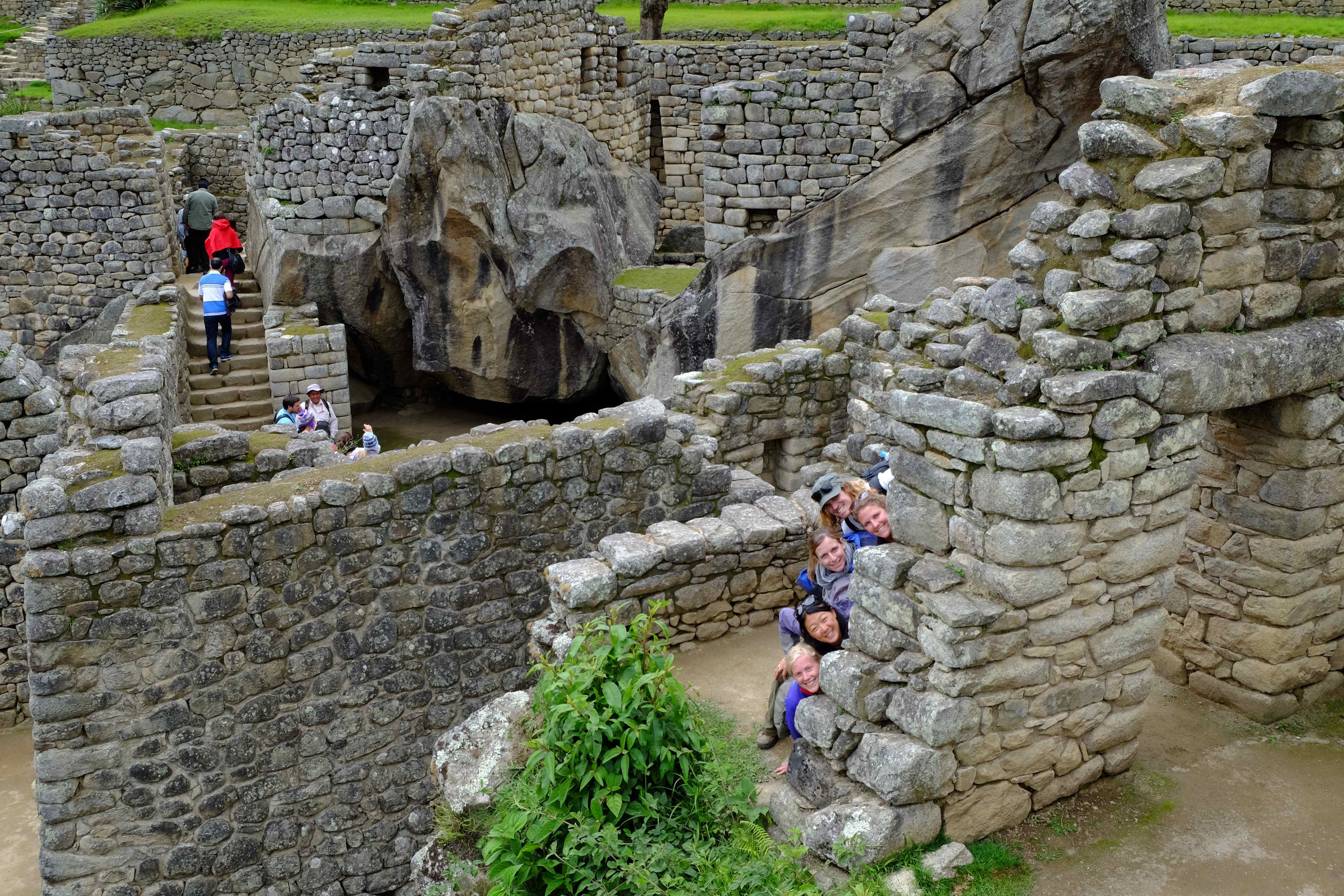
After a quick and eventful tour of the ruins we still had one more challenge ahead…Machu Picchu Mountain. After four days trekking it a really tough climb (we never wanted to see stairs again!), but gave us great views of the ruins and Waynapicchu mountain from on high.


Views of the ruins from Machu Picchu Mountain

On the way up, we ran out of water and had to refill our bottles an hour or so later from the ancient fountains that are still working. Appartenly the water comes from a spring a little further up the mountain and is channelled using ancient incan technology through the ruins. Needless to say, by the looks of the channels, we made sure to use water purifying tablets!
Once back in Cusco after we took a few days to rest and recover from all the walking. A warning to our vegetarian and animal loving friends or those who kept guinea pigs as pets you may want to stop reading this post here.
Throughout Ecuador & Peru one of the local delicacies which we had yet to eat is the Cuy (Guinea Pig) and after finding a great local Quinta (a restaurant with internal patio popular with local families) we felt the time was right. It was pretty tasty but contrary to popular belief, they look just the same alive as the domesticated ones in Australia, so I was feeling pretty guilty for my cute little pets from back in the early 90s!!

Still wishing for a bit more recovery time, but keen to make it to Argentina before Christmas, we set off on yet another overnight bus enroute to the much anticipated Bolivia and Lake Titicaca.
As you can see we’re not really keeping up to date with the blog posts, we’re in Santiago de Chile now and have just spent almost the entire last month living it up, non-backpacker style, with family and friends. You’ll hear all about it in a few months!! :)
Hugs all round,
Xavi & Sal

