Blog Archives

Bolívia I – Lake Titicaca & La Paz
We were really excited to enter Bolívia, as our book-guide puts it, a country of superlatives: one of the coldest, warmest, windiest and steamiest, with some of the driest and saltiest places in the world.

Lake Titicaca
It’s also the cheapest and poorest in South America, despite being one of the richest in natural resources. It has the highest indigenous population at around 60%…it has everything but coast, the only South-American country together with Paraguay with no access to the ocean.

However, they don’t lack water in the sacred Lake Titicaca, our first destination. This lake is the largest in volume of water in South America and the highest navigable in the world at 3,812m.

Barge crossing at Lake Titicaca – Our bus looked so unstable on it!
Accompanied by two Italian brothers, Francesco and Fede, we took the ferry to Challapampa, a small comunity at the north side of Isla del Sol, the biggest island in the lake. We hiked together, shared wine and trout meals and had a good laugh, it was really nice to meet you guys!

The small community of Challapampa – Isla del Sol


Isla del Sol is also very rich in Incan culture as it was a major pilgrimage destination. The name of the lake derives from the sacred rock Titikala which we found in the ruins on our hike the next day.

Offerings on the Titikala Rock

A truly mystical place

Quechua and Aymaras believe that the god Viracocha created human kind and the Sun where the rock is. A few metres down the track lies Chinkana (labyrinth), a huge stone complex thought be a training center for Inca priests. We loved getting lost in their maze-like corridors!


Lake Titicaca from the Chinkana ruins
On our way back we witnessed something really special: an iridescent cloud! When we were starting to believe that weird things really happened on the island, a local confirmed that is a well known sign for upcoming rains.


Happy times with Francesco and Fede!

Finishing the hike with a swim in the lake.
And the rains were caught by the many hills on the island containing agricultural terraces, which adapt steep and rocky terrain to make the most of precipitations.


The next day we went to Yumani, a larger community in the south, home to the Inca Staircase, 206 steps that you have to endure with your heavy backpacks – or a water pipe if you decide to help an old local fellow carrying it by himself – to get to the town and your accommodation.

The Incan Staircase

More incan ruins, close to Yumani

There’s also a sacred fountain with 3 different spouts. We were told that each one is believed to give its drinker the ability to speak a language, Quechua, Aymara or Spanish. I tried the 2 that had water that day and it kind of worked, I can speak Spanish!!

Quechuan kids want to learn languages too!

Isla del Sol gave us some of the best sunsets of this trip
Back to the mainland we said goodbyes to Fede and Francesco and took a turn from the main touristic path to Sorata, a little town nestled in the Andes and crowned by el Nevado de Illampu, over 6,300m high. Can you believe that the clouds didn’t allow us to take a single decent picture!?

But we found a crazy goat that wanted to pick a fight…
Still tired from the Salkantay trek, we enjoyed the calmed atmosphere of the town and opted for a half day hike to las Grutas de San Pedro, a beautiful cave very well maintained by the small community. The cave even has a lake that you can navigate by pedal-boat.

Multicoloured hills on the way to the Grutas

From peaceful Sorata we moved to bustling La Paz, the highest capital city in the world. The city is shaped as a bowl and its elevation goes from 3,200 to 4,100 at the altiplano (average altitude is 3,660m).

La Paz and Mt Illimani (6,402m)

Plaza Murillo, Government house and Cathedral – La Paz

The arms of the clock in Plaza Murillo run anti-clockwise. The Government wants Bolivians to treasure their cultural differences and challenge themselves to think differently

To visit the city we followed a self-guided map, starting in Plaza San Pedro, where apart from your usual church, a block is occupied by the famous San Pedro prison. Sal passed up the chance to visit it 9 years ago when prisoners were allowed to make money by giving tourists a prison tour. It became such an attraction that some guests even stayed overnight!
Luckily Sal didn’t go in because, as you can imagine, one of this tours didn’t end up nicely and now it’s totally forbidden (a backpacker wrote a book called “Marching Powder” about his voluntary 4 month stay in the prison).

Too many inmates and plenty of stories in just a city block
The prison is famous for hosting 2,500 inmates and their families (it was built to hold around 400!). Inmates have to pay for everything and are able to buy real estate. The poorest cells hold many inmates and have no toilets. The best cells are duplex apartments with wifi, cable TV and even jacuzzi that go for around AU$900/EUR640 per month. Inmates run businesses in there (hairdressers, tailors, grocery stores,…) and even Coke has negotiated an exclusivity deal with the prisoners to be the only soft drink sold in the prison. Inmates even have to pay to get into prison!! (AU$3.6/EUR2.5).
Los “Lustrabotas” are another sign of identity of the city. Each one of the estimated 3,000 in La Paz treasures and defends (often fights for) their space on the footpath. They cover their faces to protect their identity and, unfortunately, lots of kids miss school to try to make money this way.

Lustrabotas in Plaza Murillo

Street art in the Paseo de los limpiabotas
If you like markets, this is your city. Apart from the typical artisanal stuff, the Witches Market is probably the oddest and most fascinating one.

Market stall at the Witches Market – La Paz

Despite its central location and colourful set-up it’s not meant for tourists, locals buy there all the time.

There you can find all sorts of potions, counter-curses, dried llama fetuses (you’re supposed to offer it to Pachamama by burying one in the foundations of your place for good luck and protection – of course) or dried toucan beaks, intended to cure ills and protect supplicants from bad spirits.

Dried llama fetuses

Crazy traffic and maze-like streets made public transport a nightmare until they built the super-modern Teleférico (cable-car) in May 2014, connecting far sections of the city in a few minutes ride. The Teleférico took us to El Alto, a neighbourhood at the top of the bowl, which hosts La Feria del 16 de Julio on Sundays.

The 10min ride to El Alto used to take more than 1hr by car
This is the biggest market we have ever seen, as most of the streets of this suburb are packed with different stalls. Each street specialises in different goods, from hardware, toys, food, furniture, shoes, mountain gear, animals, there’s even a roundabout dedicated to vehicles!

Feria del 16 de Julio
Sal and I couldn’t miss the food market, Mercado Lanza. The busiest place with locals was our choice and we had to wait and fight for a spot but we were rewarded with a massive “Plato Paceño” which combines cob of corn, fried cheese, bean pods, chicharrón, potatoes and hot sauce. No cutlery needed.

Plato Paceño – make sure you’re hungry before ordering it!
You can rarely find a supermarket in La Paz and all the big fast-food chains that tried to enter the Bolivian market failed. Almost everyone buys fresh produce and have US$3 meals at the local eateries from the markets.

Plaza Santo Domingo – no McDonalds and KFCs here!
Cholitas are the local indigenous women, famous for their attire. The bowler hat was introduced by British Rail workers when the mining industry was booming. A large shipment of these hats arrived from Italy in the 1920’s; Italians figured since people are smaller in Bolivia, their heads would be too…but they wouldn’t fit their normal-sized heads and they had to convince women that small hats were the latest fashion for women in Europe.

Cholita chilling at Plaza Murillo – La Paz
100 years later the trend continues… A designer hat can cost up to US$1,000 and, apart from being used as a social status symbol, it also functions as a relationship status: wearing the hat on the side means she’s single or widowed; if on the top, she’s married or taken.

Beautiful Calle Jaen
Bolívia also holds another World Guinness Record for having the most political leaders in the shortest amount of time, between 1825 to 1982 there were 188 coups d’etat.

However, Bolívia has found stability with Evo Morales, the first indigenous president. While he has helped to diminish poverty, illiteracy and racism drastically (the indigenous flag “whipala” is now the second flag of Bolivia), he also has a reputation for enjoying his position of power…he put himself in the starting 11 of the national soccer team for a game!

Whipala, the indigenous flag
One of the activities in my bucket list for this trip was riding the Carretera Yungas, best known as the “Death Road“. This gravel/dirt track covers 69km stretch between La Cumbre (4,650m) and Coroico (1,200m).

Starting our descent from La Cumbre (around 5°C). This is a paved section of the excursion, not the Death Road yet.

Celebrating we were still in one piece!

This road is legendary for its extreme danger. Based on the ratio of death per mile, on an average, 26 vehicles plummet over the edge each year, claiming more than 100 lives.

Sal geared up and ready for more!

The estimation is that 200 to 300 travellers were killed yearly along the road. With these numbers, in 1995, the Inter American Development Bank christened this highway “The Most Dangerous Road in the World”.

One of the famous cliff-turns

Closer to the end – around 30°C
The road is way safer now with the opening of a paved road 10 years ago reducing the vehicle traffic, but we still enjoyed the thrill. So much fun and another dream coming true!

Great views of Coroico from the road

We have more adventures in Bolívia to tell you but we’ll wait to the next post, this one might hold the record for the longest so far!
Love, Sal & Xavi

Perú II – Cusco & the great Machu Picchu
We arrived in Cusco after 23hrs on a bus and over 40hrs since last sleeping in a real bed in Huaraz and it still managed to impress us! Cusco was the capital of the huge Inca Empire that spread from Perú outwards to include Ecuador, Bolívia, Chile and even parts of Colombia and Argentina! They built the city in the shape of a puma (one of the sacred animals) with the important temples forming specific parts of the animal. Today, thanks to their awesome building skills, many of the Incan Walls and temple foundations are still standing (albeit under the newer buildings) which makes for a pretty cool city to walk around and explore.

Cusco’s Plaza de Armas – it sits between the puma’s legs apparently!

Arco de Santa Clara

San Blas Neighbourhood
The Spanish invaders appreciated the work of the Incan builders so much, that they saved the foundations of the old Inca temples and used them to build their churches and other important buildings on top.

Spanish church built ontop of Q’orikancha (Temple of the Sun) – the heart of the puma.

Incan stone foundations mixed with new techniques

The famous 12 angled stone!
Cusco (in English) or Cuzco (in Spanish) is by the way the adaptation of the original Quechua word Qosqo, believed to mean “the centre or navel of the world”.
We found the local walking tour for tips (they’ve all been great so far!) and got the introduction to the main sites. As a bonus, on the tour we met an Aussie couple, Xavier & Hannah and American friends Rosie & Annie who had the same plans as us to hike the Salkantay trek to Machu Picchu in the following days. So together we decided on an agency making the most of a bit of group bargaining power and set about preparing our gear.

On the walking tour we also learnt to make Causa Limeña – Mashed potato combined with chicken (or tuna), mayo and herbs – tasty!

Local artisan in San Blas Neighbourhood

Pachamama sculpture in the Coca Museum – Cusco
Part of the preparation involved heading to the local markets to stock up on coca leaves to help us with altitude. They sell the dried coca leaves in the local markets from huge green plastic sacks, for about a $1 a bag. The local people have chewed coca leaves for centuries to suppress hunger, thirst and fatigue and also give them to the gods as offerings.

The Peruvians told us to take 5 or 6 leaves, fold them and put them in the side of the cheek and suck for half an hour or so…can’t say they taste amazing, but it’s not too bad. We also don’t know if they really work for altitude sickness or not because we didn’t get it, but they were a welcome ritual for the hike.

Local food market
These days the official Inca Trail has become so popular and regulated (500 people per day max) that it needs to be booked at least 3 months in advance, and since I walked it back in ’05 we wanted to get to Machu Picchu by an alternative route. From the various options, we picked the Salkantay Trek which is a 5 day trip, where you camp and walk 65kms through the Cordillera Vilcanota to arrive at Aguas Calientes to visit Machu Picchu.
The tour started in Mollepata, 90kms away from Cusco. We walked around 21km on day 1, crossing Andean towns and stunning views, making our way up to Soraypampa (3,900m), the base of the Salkantay Mountain, where we camped. Coca teas, soups and the good company of our 16 other fellow hikers kept us warm.

Day 1 on the trail

Salkantay Mountain

The second and probably best day of the trek where we hiked over the Salkantay Pass at 4,600m had a damp but rather amusing start. After donning all the rain gear and setting off, we were just a few steps out of the settlement where we camped and in the paddock to the side we got to witness how mules are made!! The horse & donkey’s owner seemed just as amused by our facial expressions as we were by the spectacle!!

Authentic river crossings & great mountain climbing weather!!
As we climbed up to the pass, the rain gradually turned into snow, so yet again Pachamama decided that we would get no views in return for our climbing efforts. We only stayed a few minutes at the top to take some photos before continuing on to the lunch spot all cold and wet, and promising to make some more offerings to get good weather for the Machu Picchu day.

Salkantay Pass!

Heading down the other side of the pass…cold & wet

The following days we hiked down to the bottom of the valley through jungle areas around the Urubamba River with loads of fruit trees, including the grenadilla (a new favourite fruit – like passionfruit but better!). It was bizarre to go through so many different terrains and climates in such a short space of time!

Day 3 – heading down into the jungle


Trying to make & play panpipes straight from the plant – harder than it looks!

The trekking crew

Day 4 – following the scenic railway to Aguas Calientes

Tabea, Annie, Xavier, Hannah, Rosie & Sal with the side of Machu Picchu barely visible at the top left

Dogs on a mission

Aguas Calientes Town, at the base of Machu Picchu

Statue of Pachakutiq Inka Yupanki, the ninth Inca of the kingdom of Qosco, a charismatic leader that expanded the Inca empire
On the last day we had another early start to walk the last 8kms to Machu Picchu for sunrise. Leaving Aguas Calientes town in the dark, we were joined by the pack of local dogs who were super excited to have company for the walk up apparently 1,770 steps (we were too tired to count!) to the gates of site.

We missed the real sunrise, but seeing the sun coming over the mountains to hit the ruins was still pretty cool.
The most accepted theory is that Machu Picchu was a royal estate and place of learning. It’s remarkably well preserved thanks in part to the fact it was never discovered by the Spanish, only being officially “discovered” by Hiram Bingham in 1911.


Local lawn mowers at work

Local lawn mower taking a break

Temple of the Sun

Temple of the 3 Windows

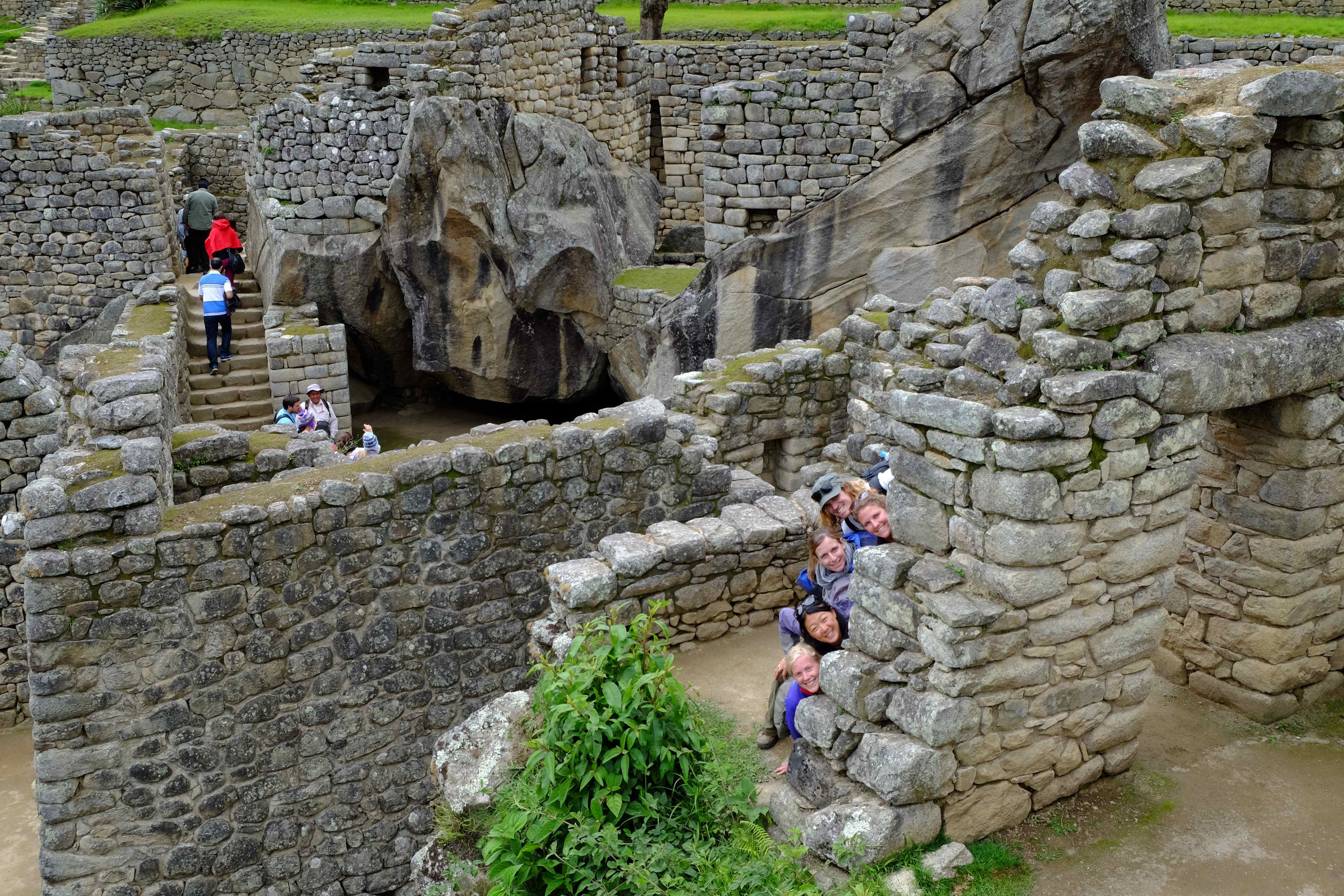
Temple of the Condor – the flat rock on the ground is the condor’s head & neck with the big rocks behind as the wings
After a quick and eventful tour of the ruins we still had one more challenge ahead…Machu Picchu Mountain. After four days trekking it a really tough climb (we never wanted to see stairs again!), but gave us great views of the ruins and Waynapicchu mountain from on high.


Views of the ruins from Machu Picchu Mountain

On the way up, we ran out of water and had to refill our bottles an hour or so later from the ancient fountains that are still working. Appartenly the water comes from a spring a little further up the mountain and is channelled using ancient incan technology through the ruins. Needless to say, by the looks of the channels, we made sure to use water purifying tablets!
Once back in Cusco after we took a few days to rest and recover from all the walking. A warning to our vegetarian and animal loving friends or those who kept guinea pigs as pets you may want to stop reading this post here.
Throughout Ecuador & Peru one of the local delicacies which we had yet to eat is the Cuy (Guinea Pig) and after finding a great local Quinta (a restaurant with internal patio popular with local families) we felt the time was right. It was pretty tasty but contrary to popular belief, they look just the same alive as the domesticated ones in Australia, so I was feeling pretty guilty for my cute little pets from back in the early 90s!!

Still wishing for a bit more recovery time, but keen to make it to Argentina before Christmas, we set off on yet another overnight bus enroute to the much anticipated Bolivia and Lake Titicaca.
As you can see we’re not really keeping up to date with the blog posts, we’re in Santiago de Chile now and have just spent almost the entire last month living it up, non-backpacker style, with family and friends. You’ll hear all about it in a few months!! :)
Hugs all round,
Xavi & Sal

